 Course Duration: 5 days, including lecture-based modules and hands-on exercises
Who Should Attend:
Geologists, Geophysicists, Exploration/Production Managers, and Reservoir Engineers.
Course Summary:
During the exploration process (and for that matter development process as well) understanding of the subsurface geometry, incorporating both structural and stratigraphic framework, is essential to understanding the 4D development of potential reservoirs. Subsurface maps represent the cornerstone of data presentation and information transfer in oil and gas exploration/development, geothermal, and carbon capture, whether well log based, seismic based, or both. We focus here on the fundamental principles and methodologies of accurately conveying critical data and information via subsurface mapping.
Course is practically based, including integrating multiple datasets, quick-look and advanced techniques for critically analyzing/reviewing key maps (including your own and those of others), and benefits/drawbacks of modern computing. Numerous exercises supplement primary lectures for extensive interactive, hands-on experience.
Tentative Outline:
- Review of and integration of various data types (well and seismic, and other data types)
- The “need” for sound subsurface mapping
- Case examples of integrated subsurface studies
- Well log analysis, including log types, correlation of well logs, and extraction of relevant subsurface data, including thickness corrections and logs
- Brief review of key log types, including gamma ray, spontaneous potential, resistivity, porosity logs, and others.
- Azimuthal (image) logs – wireline (FMI-type and ultrasonic) and LWD (e.g., gamma ray, density, caliper, resistivity, etc.)
- True dip, apparent dip, and relative dip
- Structural and stratigraphic aspects
- Log correlation
- Lithostratigraphic and chronostratigraphic correlation
- Correcting for dip and/or deviation effects
- Structural and stratigraphic applications
- Data extraction
- Depth, thickness (measured versus vertical versus perpendicular), net versus gross sand/carbonate, pay thickness, etc.
- Seismic analysis, including 3D, time-lapse, and attribute analysis
- Brief review of principles of reflection seismology
- 2D versus 3D (and time-lapse) interpretation/mapping concepts
- Attribute analysis
- Seismic petrophysics
- Hydrocarbon indicators and mapping
- Fundamentals of contouring
- Rules of contouring
- Techniques of contouring
- Styles of contouring
- Computer versus interpretative
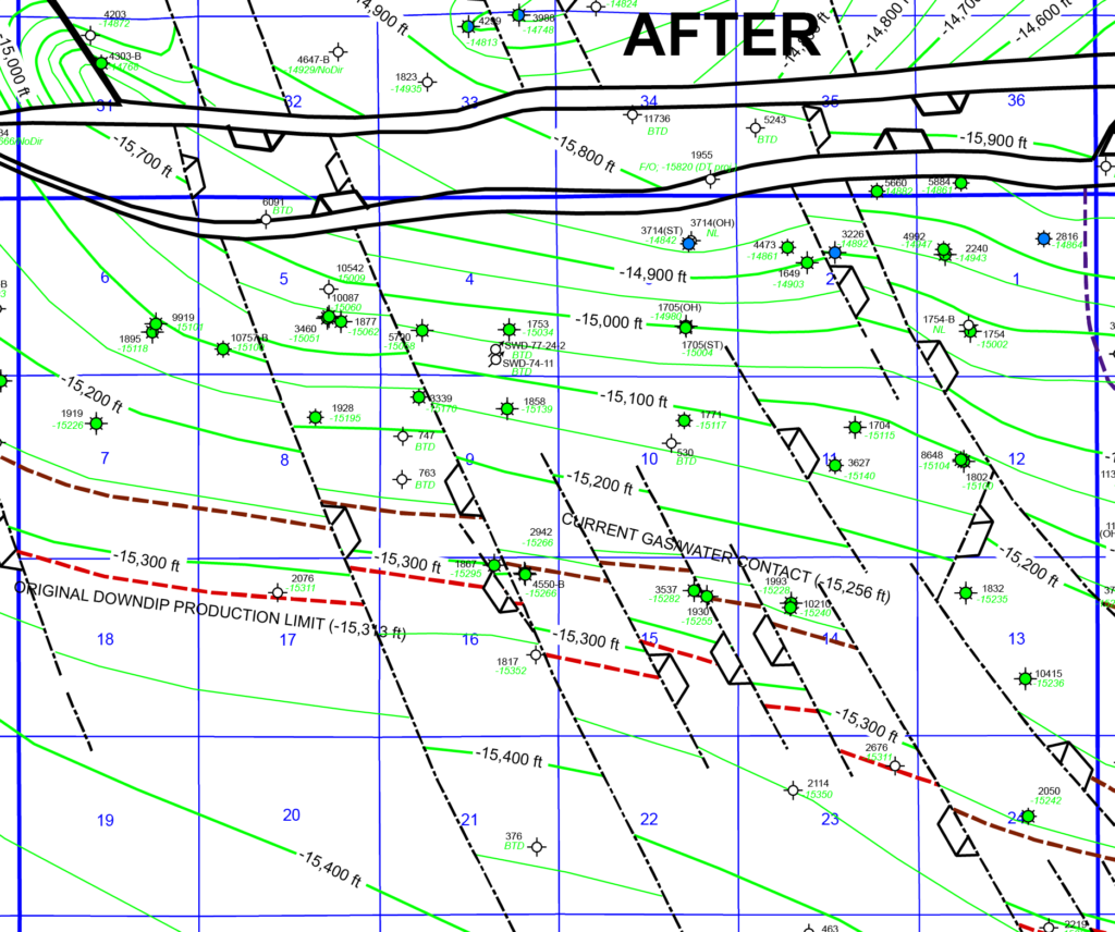
- Construction of and interpretation of fault plane, structure contour, and thickness maps
- The fundamental structure contour map
- Mapping the fault plane(s)
- Mapping reference horizons
- Mapping reservoir horizons
- Interval, isochore/isopach, and pay thickness maps
- Computerized techniques – benefits and drawbacks
- The fundamental structure contour map
- Integrated mapping and cross-section construction, and other data presentation forms
- Map/section synchronization
- Includes quick-look techniques of verification
- Structural versus stratigraphic cross-sections
- Facies maps, fence diagrams, block diagrams, etc.
- 3D visualization
- Map/section synchronization
- Fault juxtaposition and seal analysis
- Fault characterization, from 3D seismic to well log to core
- Fault juxtaposition diagrams
- Calculations of shale smear and other seal factors
- Integration of LWD data for geosteering and reservoir navigation applications
- Real-time subsurface mapping
- Modifying the geological model with new data
- Changing the borehole trajectory
- Structural, stratigraphic, and fluid aspects
Course is designed from an applied standpoint, with numerous examples and hands-on exercises from the petroleum industry.