Consulting
James Willis has been an independent consultant for over 30 years, offering diverse geoscience consulting services for supermajors to one-person shops. Primary activities include subsurface mapping and reservoir characterization, seismic interpretation, petrophysics, and prospect review/evaluation. A sampling of previous activities is highlighted below.
For more information, please email info@applied-geoscience.com.
Subsurface Mapping Project and Reservoir Characterization Study, US Gulf of Mexico
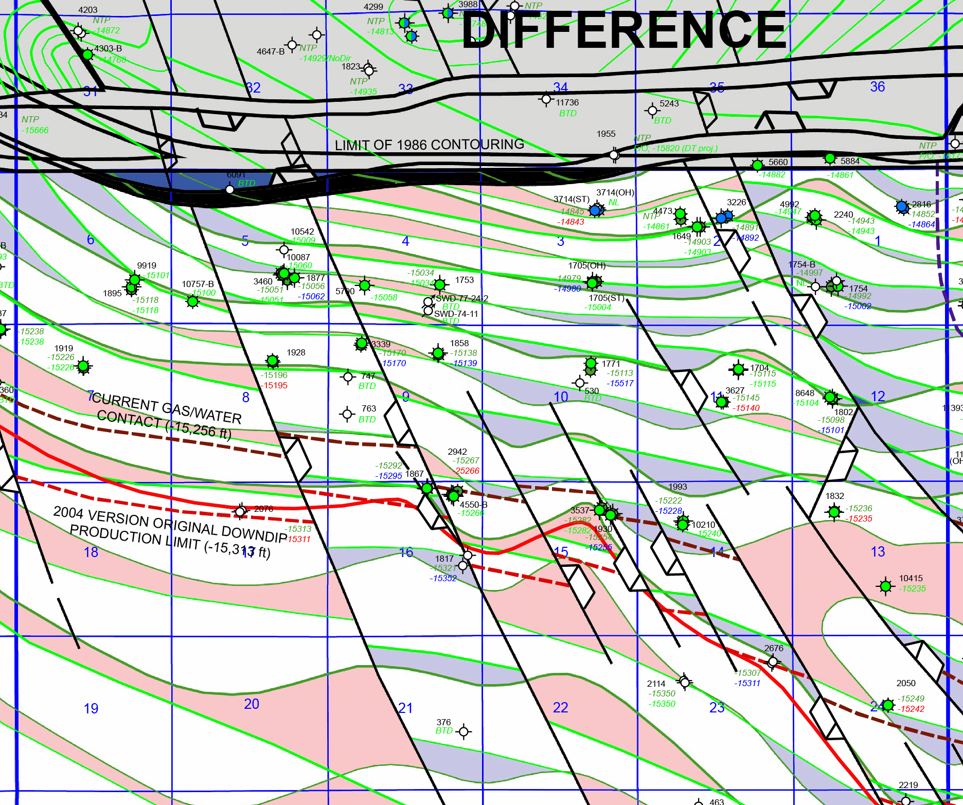
Due to a failed field-wide unitization attempt, we were tasked by a supermajor to reevaluate the general field area through data QC and correction, subsurface mapping, and reservoir characterization. A key result from this work was the identification of a small-displacement fault system that pervaded the field, causing reservoir compartmentalization due to fault control on dolomitization. Adjacent image shows a portion of the Smackover structural contour map of the field, illustrating the original mapping, our revised mapping, and a difference map (red indicating shallower depths and blue deeper). These small-scale faults (10–25 ft vertical separations) were identified by discovery of Haynesville growth faulting using caliper logs (standard log resolution precluded fine-scale stratigraphic correlations). These small-scale faults created local seepage reflux conditions due to evaporation and gypsum precipitation in grabens with recirculation of Mg–enriched fluid into Smackover carbonates especially on adjacent upthrown blocks causing enhanced dolomitization. This discovery explained many significant production differences of wells, including a pair about 100 m apart. These faults may be controlled by thickness variations of the deeper Norphlet dunes. In addition, numerous untapped dolomitized stringers were identified.
Advanced Shale Distribution Analysis in Reservoir Sandstone, Onshore Louisiana
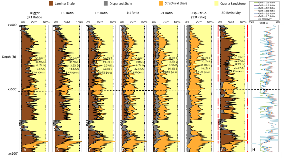
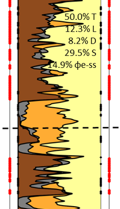
We performed a shale distribution analysis (laminar, dispersed, and structural shale) for a small independent company to better characterize a productive sandstone reservoir. The adjacent composite log illustrates key elements of this project. Classic shale distribution methodology (Thomas-Stieber/Juhasz) is represented in track A (either laminar-dispersed or laminar-structural models dependent upon position on a porosity vs. Vsh crossplot). For the position indicated by the dashed line that methodology yields an effective porosity of 23.6%, which is the most optimistic endmember of a range of potential shale distributions. Our methology considers the most pessimistic dispersed-structural endmember (track 6, yielding an effective porosity of 12.5% at the dashed line) as well as potential intermediate values in between (tracks 2–4). Overall, tracks 1–6 represents the overall possible range of shale distributions from a standard triple-combination log suite. In this example, however, we used a 3D resistivity anisotropy log to constrain laminar shale volume (Vsh-lam), which allows for full calculation of the tri-shale distribution of laminar (brown), dispersed (grey), and structural (orange) shale volumes as illustrated in track 7 (highlighted in bottom image). In this example, although the point lies nearly upon the laminar line of a porosity vs. Vsh crossplot, suggested high-quality sand fraction, the tri-shale analysis incorporating resistivity anisotropy (track 7) indicated unfortunately a much poorer quality reservoir with only 14.9% effective porosity. Track 8 shows the effective sandstone porosity of all models including the final track 7 result.